|
ATV Trails Books Maps & Guides
|
||||
|
These books are the books that
I use as guides when I am in Colorado and Utah. I highly recommend
these books to anyone thinking of going to these areas. Though these
books are for Jeeps most of the trails can be ridden by ATVs and
Motorcycles 770-463-2346 All
Items are shipped next business day via USPS Priority Mail
|
||||
|
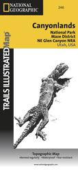
246 - Canyonlands National Park - Maze/Glen Canyon This Trails Illustrated topographic map is the most comprehensive and complete recreational map for the areas south of Moab, Utah. The map shows all trails, campsites, and recreational features, plus ratings and mileage for mountain biking trails and junction-to-junction road and trail mileage.Coverage area includes Moab, Dead Horse Point State Park, Behind the Rocks WSA, Hurrah Pass and Canyonland's White Rim; highlighted Jeep Safari Trails from Moab to Canyon Rims Recreation Area; and detailed 1:35,000 scale insets of Moab, Moab Rim, Poison Spider Mesa, Gold Bar Rim, and Gemini Bridges Area. All data is updated to reflect road closings, new trails, and campground relocation. Printed on waterproof, tear-resistant material with a plastic coating that offers supreme durability for your next outdoor adventure. Scale = 1:70,000 This Map includes many Trails Covers in "Guide to Moab, UT Backroads & 4-Wheel Drive Trails "
|