|
ATV Trails Books Maps & Guides
|
||||
|
These books are the books that
I use as guides when I am in Colorado and Utah. I highly recommend
these books to anyone thinking of going to these areas. Though these
books are for Jeeps most of the trails can be ridden by ATVs and
Motorcycles 770-463-2346 All
Items are shipped next business day via USPS Priority Mail
|
||||
|
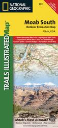
National Geographic Map 501 This Trails Illustrated topographic map is the most
comprehensive and complete recreational map for the areas south
of Moab, Utah. The map shows all trails, campsites, and
recreational features, plus ratings and mileage for mountain
biking trails and junction-to-junction road and trail mileage. This Map includes many Trails Covers in "Guide to Moab, UT Backroads & 4-Wheel Drive Trails "
$11.95 |