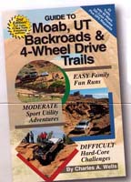
Guide to Moab, UT
Backroads & 4-Wheel Drive Trails
 2nd
Edition 2nd
Edition
55 Trails • 60 maps
• over 335 color photos • 224 pages

Only $27.95
Closeout Special Now only
$23.95, book has been updated with a 3rd edition but this book is in no way
obsolete.
Covers 55 exciting
trails around incredible Moab, Utah, including trips inside Canyonlands and
Arches National Parks. Also features most trails from the annual Easter Jeep
Safari, including favorites like Golden Spike, Pritchett Canyon, Hell's
Revenge, Poison Spider and Moab Rim. Twenty-eight trails are suitable for
most stock sport utility vehicles. Includes GPS Waypoints. This is a
great guide for both ATVs and Jeeps.
This book has been
completely redone and updated by author Charles A. Wells. Expanded to 55
trails with 10 all new. Stunning full-color shaded relief maps show every
contour of Moab’s rugged backcountry, including trails inside Canyonlands
and Arches National Parks. Over 335 high-quality color photos. Thirty-five
easy and moderate routes suitable for most high-clearance sport utility
vehicles and pickup trucks. More Easter Jeep Safari trails including Strike
Ravine and Dome Plateau. New format for GPS puts waypoints next to every
map. |
|
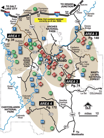
Complete Trail
Listing
AREA 1
Northwest Moab & Arches National Park
1. Book Cliffs,
Sego Canyon (E)
2. White Wash Sand Dunes (M)
3. Tower Arch (M)
4. Tusher Tunnel (E)
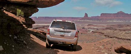
5. Hidden Canyon Overlook (M)
6. Hidden Canyon (E)
7. Bartlett Overlook (D)
8. Bartlett Wash Road (E)
9. Sevenmile Rim (D)
10. Rainbow Terrace (M)
11. Secret Spire, Dellenbaugh Tunnel (M)
12. Spring Canyon Point (E)
13. Spring Canyon Bottom (E)
14. Hey Joe Canyon (M)
15. Mineral Point (E)
|
AREA 2
Central Moab
16.
Gemini Bridges (E)
17. Metal Masher (D)
18. Long Canyon (E)
19. Bull Canyon (M)
20. Gold Bar Rim (D)
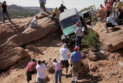
21. Poison Spider Mesa (D)
22. Golden Spike (D)
23. Cliff Hanger (D)
24. Hurrah Pass (E)
25. Moab Rim (D)
26. Pritchett Canyon (D)
27. Kane Creek Canyon (D)
28. Behind the Rocks (D)
29. Strike Ravine (D)
30. Picture Frame Arch (E)
31. Flat Iron Mesa (D)
32. Hell’s Revenge (D)
33. Fins & Things (D)
34. Sand Flats Road (E)
35. Steel Bender (D)
|
AREA 3
East Moab & Manti-La Sal National Forest
36. Onion Creek, Fisher Towers (E)
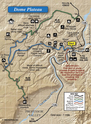
37. Dome Plateau (M)
38. Top of the World (D)
39. Dolores River Overlook (E)
40. Rose Garden Hill (D)
41. Thompson Canyon, Polar Mesa (M)
42. Castleton Gateway Road (E)
43. Geyser Pass (E)
44. La Sal Pass (M)
AREA 4
Southwest Moab & Canyonlands National Park
45. Potash Road, Shafer Switchbacks
(E)
46. White Rim (M)
47. Lathrop Canyon (M)
48. Chicken Corners (M)
49. Lockhart Basin (D)
50. Lockhart Canyon (M)
51. Canyon Rim Overlooks (E)
52. Colorado River Overlook (M)
53. Elephant Hill (D)
54. Lavender Canyon (M)
(M) 55. Beef Basin (E)
|
 |